Facebook Acquires Mapillary An Alternative To Google Maps StreetView
Google Maps not only contains a lot of information, but also very extensive image material in the form of satellite images, user photos, and, of course, Streetview images. After Google had little competition in this area for many years, the market for photographed streets is now moving again: Facebook has taken over the Streetview alternative Mapillary, which is now to be further expanded.
Google Maps Streetview is a very practical tool for getting to know foreign places in advance with a click of the mouse and is therefore constantly being expanded and updated by Google.
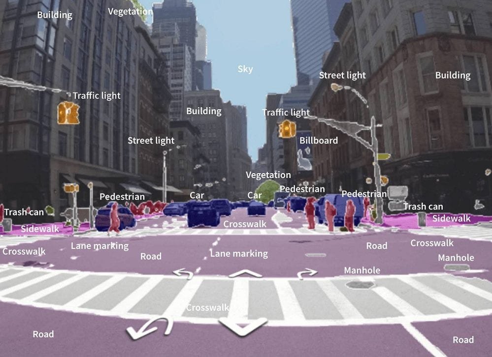
The Mapillary platform has set itself the goal of collecting detailed street photos worldwide and making them available to all users free of charge – i.e. an open street view. The project has been very popular in recent years and, with the help of the huge community, covers almost all inhabited areas of the world – and in many cases even several times.
Now the company has announced that it has been sold to Facebook. The purchase price was not mentioned as usual, but it was announced that there will be no changes to the platform for the time being – this is not a big surprise either. So far, Facebook has not necessarily appeared as a card service, even if cards with addresses are integrated into many Facebook pages. Now you can probably expect that street shots will also be found there in the future.
From the point of view of the available image material, Mapillary is currently the largest Google Maps Streetview competitor, in which Amazon showed great interest a good two years ago. The takeover by Facebook will surely also be watched very closely by Google, even if there are already other big competitors with Apple Maps and Bing Maps.
What happens to Mapillary
Our plan is to continue being a global platform for imagery, map data, and improving all maps. You will still be able to upload imagery and use the map data from all the images on the platform, says Mapillary.
Our OpenStreetMap commitment
Our commitment to OpenStreetMap stays. The plan is for the rights given to OpenStreetMap editors to remain unchanged and for our work with OpenStreetMap communities and companies to continue on the same path as always. Mapillary will continue to spearhead a collaborative model where all map communities, companies, cities, and others work together to keep the maps of our world accurate, detailed, and up to date.
What happens to customers and commercial uses
Historically, all of the imagery available on our platform has been open and free for anyone to use for non-commercial purposes. Moving forward, that will continue to be true, except that starting today, it also will be free to use for commercial users as well. By continuing to make all images uploaded to Mapillary open, public, and available to everyone, we hope to enable new use cases, and grow the breadth of coverage and usage to benefit mapping for everyone. While we previously needed to focus on commercialization to build and run the platform, joining Facebook moves Mapillary closer to the vision we’ve had from day one of offering a free service to anyone.
The road ahead
Although much has happened since we first launched Mapillary, we’re still just at the beginning. So much of the world still needs to be mapped, and so many of the world’s maps still require updates. As the world changes, our maps need to change with it. Together with Facebook, we’ll be able to build the tools that will keep our maps detailed, accurate, and up to date – for everyone, everywhere. Thank you for being a big part of the journey so far. We’re very excited about the future and can’t wait to build it with you.
Digital marketing enthusiast and industry professional in Digital technologies, Technology News, Mobile phones, software, gadgets with vast experience in the tech industry, I have a keen interest in technology, News breaking.